Signal 4 Location Tool
Overview
The purpose of the Signal 4 Geolocation Tool is to provide FLSHMV and FDOT with the location of crashes by placing the latitude and longitude on crash reports. HSMV transmits crash data to Signal 4 Analytics daily and they upload it to their system.
The location tool is required for all agencies on crash forms and is optional for the UTC and other forms.
The tool may be used on the forms listed below. Signal 4 does not currently collect UTC data from TraCS agencies, but they may do so in the future. Additionally, there will be a mapping feature implemented in a future TraCS release and forms must have the latitude and longitude in order for it to work.
- Baker/Marchman Act
- Boating Citation/Warning
- Call for Service (CFS)
- DUI Citation
- Field Interview Report (FIR)
- FIBRS Offense/Incident
- Parking/Ordinance
- Tow
- Traffic Warning
- Trespass Warning
- Uniform Arrest Affidavit (UAA)
- Uniform Traffic Citation (UTC)
Network Configuration
Per the Signal 4 team, the following domains must be whitelisted in order to allow their applications. The first one on the list is crucial for the Geolocation Tool.
Client Machine Configuration
In order for the location tool to work for the end user, client machines must be set up as follows:
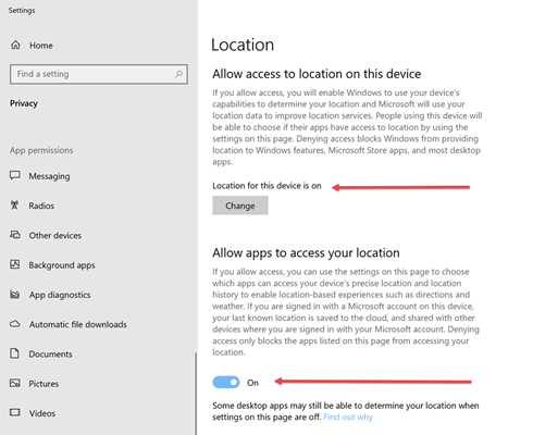
1. Location services must be turned on in Windows.
- Windows 10 - In Windows, go to Location. Both Location for this Device and Location must be On.
- Windows 11 - In Windows, go to Privacy & Security, then Location. Location Services must be On.
2. Client machines must use Chrome, Edge, or Firefox as the browser. Internet Explorer (IE) and Safari will not work.
- TraCS will launch whichever browser is set as the default on the client machine.
- If you would like to set Chrome, Edge, or Firefox as the default browser on for TraCS on a machine, instructions are on this YouTube page. This will not affect the default browser that they have chosen for Windows. If you would like a default browser setting pushed out agency wide, let us know.
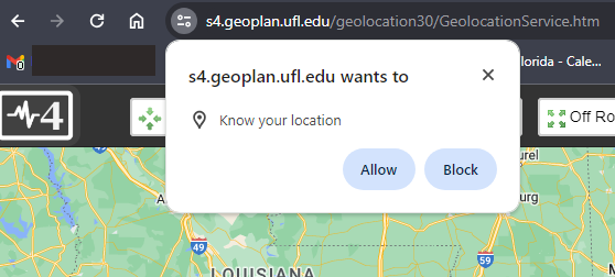
3. Machines must allow Signal 4 to access their location in their browser.
- The first time users launch the tool, they should get a pop up stating that s4.geoplan.ufl.edu wants to know their location. They must press Allow or the map will not work properly.
You may use the site below to launch the geolocation map in a browser outside of TraCS. Locations will not plot but you may use the site to test or update location permissions without having to log into TraCS and open a crash form.
https://s4.geoplan.ufl.edu/geolocation30/GeolocationService.htm
How to Use the Geolocation Tool
Troubleshooting
The Tool Does Not Launch
Be sure that you pressed the Locate button on the right side of the data bar.
The tool may have launched, but the map has minimized. Check the taskbar for the Signal 4 icon and click on it to maximize the map.
If the tool does not launch and your cursor jumps to the Zone field on the form, the issue may be with your TraCS installation. Contact your IT department to request a fresh install.
If nothing at all happens when you press the Location button, the tool does not launch and your cursor jumps to the Zone field on the form, the issue may be with your TraCS installation. Contact your IT department to request a fresh install.
Locate Button is Not Available
You must be in the At Street Address or Occurred On Street Road Highway field for the Locate Button to be available. Depending on the form the, the At Street Address field will be named Address or Address #.
Support
Signal 4 Support
s4-support@ufl.edu or 352-294-1496


