Signal 4 Location Tool
Overview
The purpose of the Signal 4 Geolocation Tool is to provide FLHSMV and FDOT with the location of crashes by placing the latitude and longitude on crash reports. HSMV transmits crash data to Signal 4 Analytics daily and they upload it to their system.
The location tool is required for all agencies on crash forms and is optional for the UTC and other forms.
The tool may be used on the forms listed below. Signal 4 does not currently collect UTC data from TraCS agencies, but they may do so in the future. Additionally, there will be a mapping feature implemented in a future TraCS release and forms must have the latitude and longitude in order for it to work.
- Baker/Marchman Act
- Boating Citation/Warning
- Call for Service (CFS)
- DUI Citation
- Field Interview Report (FIR)
- FIBRS Offense/Incident
- Parking/Ordinance Citation/Warning
- Tow
- Traffic Warning
- Uniform Arrest Affidavit (UAA)
- Uniform Traffic Citation (UTC)
Network Configuration
Per the Signal 4 team, the following domains must be whitelisted in order to allow their applications. The first one on the list is crucial for the Geolocation Tool.
Client Machine Configuration
In order for the location tool to work for the end user, client machines must be set up as follows:
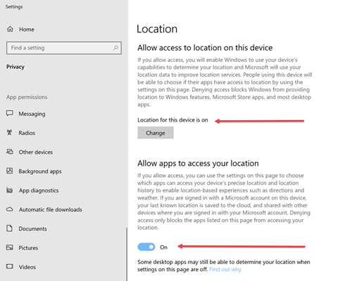
1. Location services must be turned on in Windows.
- Windows 10 - In Windows, go to Location. Both Location for this Device and Location must be On.
- Windows 11 - In Windows, go to Privacy & Security, then Location. Location Services must be On.
2. Client machines must use Chrome, Edge, or Firefox as the browser. Internet Explorer (IE) and Safari will not work.
- TraCS will launch whichever browser is set as the default on the client machine.
- If you would like to set Chrome, Edge, or Firefox as the default browser on for TraCS on a machine, instructions are on this YouTube page. This will not affect the default browser that they have chosen for Windows. If you would like a default browser setting pushed out agency wide, let us know.
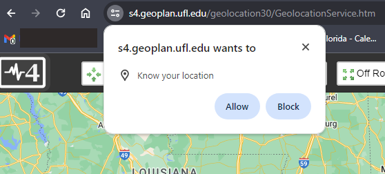
3. Machines must allow Signal 4 to access their location in their browser.
- The first time users launch the tool, they should get a pop up stating that s4.geoplan.ufl.edu wants to know their location. They must press Allow or the map will not work properly.
You may use the site below to launch the geolocation map in a browser outside of TraCS. Locations will not plot but you may use the site to test or update location permissions without having to log into TraCS and open a crash form.
https://s4.geoplan.ufl.edu/geolocation30/GeolocationService.htm
How to Use the Geolocation Tool
A training video on how to use the Geolocation Tool is here.
Troubleshooting
The Tool Does Not Launch
The tool may have launched, but the map has minimized. Check the taskbar for the Signal 4 icon and click on it to maximize the map.
If the tool does not launch and your cursor jumps to the Zone field on the form, the issue is likely with your TraCS installation. TraCS needs an agency ORI in order to launch the tool. If none is present, the map will not open. Contact your IT department to request a fresh install.
If nothing at all happens when you press the Locate button, the issue is likely with your TraCS installation. Contact your IT department to request a fresh install.
The Locate Button is Not Available
Are you in view/read mode or are you in edit mode? You must be in Edit mode in order to use the Locate button.
Is your cursor in the right place? You must be in the At Street Address or Occurred On Street Road Highway field for the Locate Button to be available. Depending on the form, the At Street Address field may be named Address or Address #.
The Map is Slow to Load
Signal 4 attempts to use the browser’s geolocation service API to initialize the map near the location of the user.
If the map is slow to load on the location tool or the diagram tool, try clearing your browser cache. Instructions on how to do that are here. When you do it, be sure to select All Time for the Time Range.
If clearing your cache does not solve the issue, you likely have a poor or slow VPN or network connection.
The Map is Blank
If the location tool launches, but the map is blank or grayed out, check to make sure you are using Chrome, Edge, or Firefox as your browser. Internet Explorer (IE) and Safari will not work.
First, clear your browser cache per the instructions on this page.
If you are already using Chrome, Edge, or Firefox, and clearing the cache does resolve the issue, change your default browser to one of the other two.
Also make sure that your location is allowed in both Windows and in your browser. See Client Machine Configuration for further information.
If your default browser is already set to Edge but the tool is launching in IE, complete the steps below.
- In Edge, go to Settings
Default Browser
Internet Explorer Compatibility
Allow sites to be reloaded in Internet Explorer mode (IE mode)
Set it to Don't Allow then press Restart.
The Map Does Not Zoom to My Location
If the location tool launches, but the map is not zooming to your approximate location, the map is zoomed out to the state of Florida, or you get an error message that the "Point must be within the State of Florida envelope," first clear your browser cache per the instructions on thie page.
If clearing your browser cache does not solve the issue, check to make sure that your location is allowed in both Windows and in your browser. See Client Machine Configuration for further information.
If you have cleared your browser cache and your location is allowed in both Windows and in your browser, the issue is with the air card on your machine or the VPN for the agency.
Per the Signal 4 Team -
When location services are enabled for the operating system and allowed in the browser, the S4 Location Tool attempts to use the browser’s geolocation service API to initialize the map near the location of the user. The inner workings of these algorithms are proprietary to each browser, which Signal 4 has no control over, and they can be thrown off by a VPN. If the browser geolocation doesn’t return a point inside of Florida, then the center of your agency’s jurisdiction is used to initialize the map instead. The Show My Location button will give the results of the browser's geolocation, so it may be necessary for officers to use the location search bar at the upper right to jump to their location on the map.
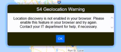
Location Discovery Error
If you get a Location Discovery error when pressing the blue Show My Location button, make sure that your location is allowed in both Windows and in your browser.
See Client Machine Configuration for further information.
Per the Signal 4 Team -
When location services are enabled for the operating system and allowed in the browser, the S4 Location Tool attempts to use the browser’s geolocation service API to initialize the map near the location of the user. The inner workings of these algorithms are proprietary to each browser, which Signal 4 has no control over, and they can be thrown off by a VPN. If the browser geolocation doesn’t return a point inside of Florida, then the center of your agency’s jurisdiction is used to initialize the map instead. The Show My Location button will give the results of the browser's geolocation, so it may be necessary for officers to use the location search bar at the upper right to jump to their location on the map.
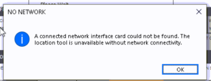
Network Error
If you are getting a pop up that states, "NO NETWORK… A connected network interface card could not be found. The location tool is unavailable without network connectivity.", this means that TraCS is attempting to obtain the MAC address as a step in verifying a good, secure connection, and nothing is being returned to it. Your network, firewall, anti-virus, and/or VPN need to be adjusted. See this page for exceptions that must be added.
Signal 4 Support
Any feedback on the geolocation tool for issues not listed on this page, requests for additions/changes to street names, or requests for map updates should be directed to Signal 4 Support.
Help Desk Phone: 352-294-1496


